Tuesday, August 31, 2010

Scott Road gets repairs


Long overdue, and I imagine very expensive, Scott Road got a makeover in the past week or so as it crosses the main path in Flat Rock, the Luscomb Path. In addition to literally tons of baseball to softball size river rock replacing a badly eroded roadbed, workers apparently also reworked some drainage on Scott Road just west of the Luscomb Path, and on the northwest side of the path.

Monday, August 30, 2010

The glowing hemlock forest

Desperate to map some trails after work before the summer is over and the woods get darker earlier, I took a 6 mile hike along the east side of Flat Rock the other night, at dusk, apparently into Falulah Park. I discovered areas that I could never picture as being in Fitchburg, especially a section of Falulah Brook that looks as if it could have been transplanted from The Basin in New Hampshire's Franconia Notch.

As I made my way up out of a valley, and knew that I was coming into familiar territory near the gorge and main path, I thought I was imagining things when I saw what looked like a vague glowing 5 foot circular area along the trail. I passed it by, eager to get to my car before things got too dark, then was drawn to double back after a few footsteps. Sure enough, a pastel, pinkish-orange light seemed to emanate from the quiet trail of conifer needles and leaves. I stood there for a few seconds trying to figure it out, feeling as if I had found something a little magical. As I looked up, there was a small break in the heavy tree canopy, and, above it was what appeared to be the only cloud in the sky, a high wispy cloud that was subtly reflecting the pinkish sunset off to the west. The two were perfectly aligned, creating the glow in a small area of trail amidst a very dark area of forest.

About 9 years ago I hiked solo up Mt. Monadnock on a foggy summer day, not intending to summit, but exploring some quiet side trails, camera in hand. As I quietly walked along the Thoreau Trail, my quiet walk was made easier by rocks that nearly paved a section of the trail. As I stepped up over a big rise, I sensed a presence, and there, face to face less than 6 feet away, stood a huge deer. I froze, and while she did too, she didn't know why. My scent was probably blowing away from her, and I was motionless despite a strong pull to raise my camera. Lacking movement and scent, I was virtually invisible to her senses. The scene lasted several minutes before she started grazing nervously, picking at the forest floor but obviously still sensing that something was not right and maybe not safe. She wandered off slowly to my right, grazing as she went, and only when she was about 25 feet away did I move my body at all. The deer quickly skittered into the thin woods.

I imagine that special things happen all the time. The forest floor glows in magical ways that most human eyes never see, and deer and every other animal no doubt feed many times a day. The key, I think, is to approach with quiet footsteps and a quiet mind that is open, so that you can perceive moments like a glowing hemlock forest, and appreciate them.

Friday, August 27, 2010

The what?


The Triangular Conservation Area? Falulah Park? While you may have never heard of them, these city-owned conservation lands are roughly in Flat Rock territory.

I've noticed a skinny triangular slice of land on Flat Rock maps before. It's just northeast of Overlook Reservoir, south of the Pipeline Path. Apparently this is the Triangular Conservation Area, according to a city document. It's .61 acres. I imagine it's a leftover having to do with early city water supply property.

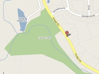
But what about the Falulah Park? I happened upon this in google mapping some nearby roads. While I can find little about it, it's about 10 acres of conservation area wedged between Rindge Road and Flat Rock land. We'll have to check this out some more.

Thursday, August 26, 2010

Some people just take a walk

While my brain doesn't always turn on or off at the times I want or need it to, it's been in an "on" mode the last few times I hiked at Flat Rock. Specifically, I've been noticing specific areas where beech predominate, or where small dense hemlock groves darken the ground. In other places, craggy rock from the size of breadboxes on up to the size of washing machines, all weighing more than any person would care to deal with, seem to have naturally collected in patches. Stone walls divide the landscape, sometimes at bizarre angles to each other. So, I've been asking myself "why," and trying to develop the ability to come up with some answers.

I've been reading a great book, "Reading the Forested Landscape," by Tom Wessels. While the Fitchburg Public Library doesn't carry it, it's available (despite cutbacks) through an interlibrary loan (once I return it). Wessels hasn't answered all of my questions, but has at least provided a framework around which to interpret what I've been seeing.

So far I've learned that most stone walls in New England were built not as property line markers, but as a means to contain livestock, and specifically sheep. Most walls were built between 1810 and 1840 when a sheep craze hit New England. While Wessels says that stone walls needed to be at least 4 feet high to contain livestock, he also notes that often brush would be piled on top to supplement the height achieved by the stone. (He notes that walls along a cultivated area often contain smaller, fist-sized rock that were forced up by frost in winter months, and removed by farmers to nearby walls.) It makes me think of some large areas enclosed by stone walls, and also some smaller clear livestock pen areas that I've seen.

There are so many clues and indicators as to past land use, and why certain species or mixes of species grow in certain areas, that it's hard to summarize in a brief blog entry, but I'm hoping to be able to take some more educated guesses about some specific areas of Flat Rock and surrounding lands over the next few months. I'll post them as I do.

So, right now we have a number of areas on our radar screen for future blogs:
-more about Girl Scout Camp Wakitatina
-a livestock pen off the Overlook Trail
-various concentrations of trees along the Pipeline Path
-an apparent good-size piece of walled-in land off Flat Rock Road, and
-the unique habitat and vegetation of the high, rocky point of Flat Rock Road, what some refer to as "The Bald."

Saturday, August 21, 2010

A little bit of Flat Rock history.


First the map

This map is dated 1870. You may notice that Overlook reservoir is not on the map. It was just in the beginning phases of being built when this map was created

Overlook was the first, built by Alvah Crocker a major landowner in Fitchburg. This was before
Fitchburg had it's own water dept.

It is interesting to note that Fitchburg had two different types of water lines a high pressure line
and a low pressure line. Overlook provide the high pressure and a smaller reservoir near by that is now filled in nearby provided the low pressure.

The excerpt below is from a book written by John Warner Barber entitled "Historical Collections Relating to the History and Antiquities of Every town in Massachusetts with Geographical Descriptions" Published by Warren Lazell in 1848.

It mentions Flat rock road as "Flat Rock" as well as Scott road. Please note that this book is in the public domain. Also please not that "Dorchester Canada" Is now known as the town of Ashburnham

This road, probably, passed the village oi Fitchburg, nearly in the same place with the present travelled way. It then wound up the hill, by Enoch Caldwell’s, over flat rock, through the land lately owned by Sylvanus Lapham, and thence to what was then Lunenburg west line, and into Dorchester Canada. John Scott had been for a long time desirous of a more direct route to the center of Lunenburg; but the town would not accede to his wishes. He accordingly procured a court’s committee, who laid the present Scott road, “to the great satisfaction of Mr. John Scott," as the records say. This road passed from the middle of Lunenburg by the log house where John Battles, Jr., now lives; then by Ebenezer Bridge's, where Deacon Jaquitt now resides, and then by Scott's own house, and so on to the road before mentioned. This Scott road was for some years quite a celebrated thoroughfare, and used to be called Crown Point road.


My thanks to Andy for his wealth of knowledge concerning Overlook Reservoir.


Friday, August 20, 2010

Thoughts along the Pipeline Path

I took a walk along the Pipeline Path at dusk earlier this week, mostly trying to map out where the side trails enter it, but also taking a few photos. Along the way a few thoughts occurred to me....
In earlier hikes, I had noticed a few areas on the uphill side of the path that seemed like they had been dug out some. Now I realize that these were probably areas that were dug out to use as fill over the brick pipeline as it progressed. In other areas, it was obvious that large rocks had been pushed aside on the downhill side of the path--probably back-breaking labor for those who made the pipeline. I imagine one crew worked ahead of the bricklayers, digging the ditch and heaving aside the rocks, while maybe another worked behind the bricklayers after the arched tunnel was made, digging into the hillside in specific areas for backfill.
Numbered stone markers are found mid-way along the trail. I had previously thought that they go out of numerical order, but from what I could tell the other night they are in order. I think the first one I spotted was "18," and the last was "28." That said, it's clear that at points the pipeline runs 10 to 20 feet off to the side of the trail, on the downhill side, and maybe there are more numbered markers along the actual pipeline.
Finally, there's at least one significant area of ledge that the workers had to get through (just southeast of the "18" marker). I'm just glad I wasn't one of those laborers, though they were probably happy to just to have a job.

Camp Wakitatina


If you have ever taken the Loop Trail around Overlook Reservoir you may have noticed a piece of asphalt located beyond the earthen dam as you enter the woods.

Being a bit curious I asked around and found out that there was once a Girl Scout Camp located there. Due to vandalism it was torn down around 1981. Below are some photo's of the camp.

Our thanks to Beth for the map and pictures.and thanks to Jim and Dennis (and the Reservoir Dogs) for there help in locating the site.

The Map


And here is what remains. The "Singing Rock" (although it was quiet while I was there)

Thursday, August 12, 2010

The Pipeline Path

I first found this opening into the pipeline of the Pipeline Path a few years ago on a hike with my daughter. It's visible in an area of the path where there is an obvious unnatural hump in the ground. A cool, damp breeze emanated from the opening, about a foot in diameter, and the ground around it was littered with porcupine quills. Somewhat nervously I held my camera down inside, half expecting to encounter some sort of animal, or to bring the camera up, look at the LCD screen, and see some eerie shining yellow eyes staring back at me. So far I'm 0 for 2 on that count--no beasts. Once I found this part of the pipeline, the name started to make sense, and so did the countless bricks that can be seen along the path. I'm guessing it carried water from Scott reservoir to Overlook Reservoir at some point, and is no longer in use. But who built it, and when? I know of a similar pipeline on conservation land in Athol that was built in the early 1900s by immigrant Italians who lived nearby in tent camps. Did the construction of the Pipeline Path pipeline have a similar origin? We'd like to know. Maybe the library or the historical society have some information. Those trips are on a "to do" list.

It's also interesting to see the numbered granite markers that can be found in the middle section of the path. They seem to go in no particular order. What do they signify?

Sometimes, it's fun to think of the pipeline is a huge wildlife Ted Williams Tunnel. I picture skunk and porcupines scurrying along, undisturbed by coyote. I can hear Rich Kirkland now...."Were just getting word of a backup in the Pipeline Path Tunnel due to an oversize raccoon." I'm sure there are other openings. I've found one likely area, but haven't explored it thoroughly.

Wednesday, August 11, 2010

What is it?

Not far behind The Highlands, near where the Pigpen Path and the Hemlock Hill Path converge, lies what appears to be a cellar hole....but it's perfectly round, and deeper than your average cellar hole. What is it? Part of a well system? Some remnant of a farm structure? We're open to educated guesses, but we'd like to hear from somebody who truly knows what it is. It contains some remnants of slate as if the structure had a slate roof, and the stone was clearly quarried, rather than just being your average New England stone wall rock.

Tuesday, August 10, 2010

They even smell new

We took a 4 mile hike through this past Sunday, north and south, back and forth along the trails. I had only been on a back way to the gorge once about 2 years ago, and was surprised that instead of jumping Scott Brook there was a newly made bridge in place. We were even more surprised to find a bridge of the same design spanning the gorge just upstream of its deepest point. They are a nice addition to the landscape, but at the same time I don't want to see the woods start to be cluttered with manmade things. Good job, somebody, but I hope you don't get too ambitious.

Monday, August 9, 2010

First Flat Rock Blog post

Welcome to the Flat Rock Blog. (Try saying Flat Rock Blog three times fast.) It's written by outdoorsmen who have hiked the trails in and around Flat Rock for years, taken photos, tracked animals, accurately mapped the trails, and who continue to explore it in all seasons.

Of course we really don't want to attract more people to the trails; we'd just as soon have them all to ourselves. We really don't want to make it easy for partiers to find places to party and have campfires, nor for people to do anything else destructive. If we're sometimes vague about information or locations, it's probably purposeful.

In the next few weeks or months we're going to assemble and publish (on-line) a map that includes all the trails in Flat Rock, Crocker Conservation Area, and nearby non-private lands. There are some good, and not-so-good maps already out there, but nothing that is all-inclusive. In keeping with our protective stance, we may leave a few things off the map, such as the location of any graves, cellar holes, or sensitive habitats.

Also on its way (once us old guys figure out the technology) are a number of photo albums, to which we hope to constantly add. We are also working on an e-mail link so you can contact us with any questions, comments, suggestions, or news flashes if you see a bear, moose, bobcat, fisher cat, or any other exciting wildlife sightings.

So, stay tuned, and we'll see you out there in the woods.